Creating, Importing, and Viewing Base Stations (Open Source Only)
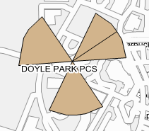
A base station list file (.lst) is a plain text file with a header line and a line-by-line delimited list of base station details. These details must be in order and can be delimited with a comma, tab, or semicolon. The first line is a header for the user and is ignored when importing the list. Each of the remaining lines is for a single base station, where the first two numbers are the decimal latitude and longitude, respectively. Next is the base station name or other identifying information. The last number is an angle, measured clock-wise from North, and is optional. Base stations sometimes have an orientation and the angle is the direction an antenna points, or the center of the beam width. Many base stations have three sectors and this would be the angle from North of the center of the alpha sector. If you look closely at the icon on the map, there are three sectors shown and one of them has a black line through the middle – this should be in the direction indicated in the .lst file (see Figure: Base Station Symbol).
Below is an example of three separate base station entries, the first of which is shown in the image below:
To import a base station list, you must be using an open source map that covers the area of the base stations. Baidu maps do not support viewing base stations.
2. Click the Import File button to find the directory and folder of the Base Stations list (.lst). When selected, the latitude, longitude and description of the site will be displayed in the list.
3. Click the Create Map Overlay to place the base station locations on to the current map.
4. Click View Base Stations on Map if Present to see if there are any base stations in the Drive Map display. Base station symbols will display on the map as shown below when this function is selected. Note that your map must cover the area of where the imported base stations are located.