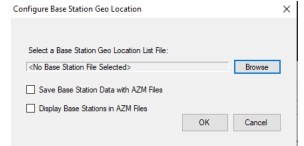
2. Click Browse button to load the desired Base Station Geo Location File into easyMap tools.
3. Check the box next to Save Base Station Data with AZM files.
• When this box is checked the Base Station Geo Location List File is loaded into the AZM map file.
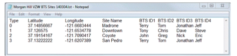
Base Station Geo Location File
The purpose of a Base Station Geo Location File is to display a known base station in a geo-enabled map when running Interference Mapping on an Anritsu Handheld Instrument.
The Base Station Geo Location File contains various information specific to a particular base station. This information includes:
• Type
• Base station’s Latitude and Longitude
• Site Name and four additional labels that further describe the base station.
These will be displayed in the first row of the file as column headers. “Type” color codes the base station icon and labels. Only four “Types” are supported – 0: red, 1: green, 2: blue and 3: black.
The file format is tab-delimited also known as tab-separated values (TSV). “Site Name” and the four other column labels will be the button labels on the instrument. This TSV file can be created and edited with a simple text editor such as Notepad. Also, files created in a spreadsheet such as Excel need to be exported to the TSV file format. Below is an image of a sample TSV Base Station Geo Location file.
Note
There is a limit to the number of label characters on the instrument. “Site Name” will be truncated to 18 characters and the three IDx labels will be truncated to 32 characters.
TSV Base Station Geo Location
easyMap Tools imports the content of the file and places it into the correct map tile of the AZM file.