1. Create the appropriate map with Anritsu easyMap Tools. Refer to Anritsu easyMap Tools. Outdoor mapping requires a GeoEmbedded map or the default grid.
2. Press the Menu key, then select the coverage Analyzer mode (P25, NXDN, dPMR, TETRA, DMR, or PTC (ITCR and ACSES)) icon or press Shift and then the Mode (9) button to open the Mode Selector dialog box. Highlight the desired mode and press Enter.
3. Open Coverage Mapping by pressing the Measurement main menu button followed by pressing the Coverage submenu key. The default grid or previous map is displayed.
a. Press Shift then System (8). Press the GPS submenu key.
b. Connect a GPS antenna to the SMA connector.
c. Turn on GPS. On should be underlined in the GPS submenu key.
d. Press the GPS Voltage submenu key to select the appropriate voltage for the antenna being used. Refer to the instrument Technical Data Sheet for voltage specifications of supported GPS antennas.
e. Press GPS info and verify that the information from three or more satellites is captured. Press Esc to close the info box.
Several minutes may be required for the GPS receiver to track at least three satellites for obtaining longitude and latitude coordinates. Tracking 4 satellites will obtain altitude information. When at least three satellites are being tracked, the GPS icon at the top of the screen turns green. Refer to the User Guide for your instrument for additional information about GPS.
Recall a Map (Indoor or Outdoor Coverage)
The instrument allows you to recall a .map file (created with Anritsu easyMap Tools). With a valid GPS signal, the current location is displayed on an outdoor map, or an arrow shows the direction of the current location if it is outside the map coverage area. With an indoor map, you position the cross at the current location by using the touch screen, or by using the Arrow keys, and then pressing Enter.
Connect the USB flash drive to the instrument. It must have the map file (or files) that you created in Anritsu easyMap Tools.
1. Press the Measurement main menu key, then press the Coverage submenu key.
2. Press the Save/Recall Points/Map submenu key.
3. Press Recall a Map and select the appropriate map from the USB flash drive.
4. Use the arrow keys to scroll down to the desired map and press Enter to select.
5. The new map file will be displayed and the current location (if within the GPS boundaries of the displayed map) is shown as a plus sign with outdoor mapping.
6. If the current location is outside the map boundaries, an arrow indicates the direction of the current location in relation to the displayed map.
If you do not see the USB drive in the Recall menu:
1. Press the Refresh Directories submenu key.
2. If the drive is still not visible, exit the menu, then remove and reconnect the USB drive.
3. Press Recall a Map again.
4. If the drive is still not visible, reformat the USB flash drive in FAT32 format, then copy the map files to the reformatted drive.
Recall the Default Grid
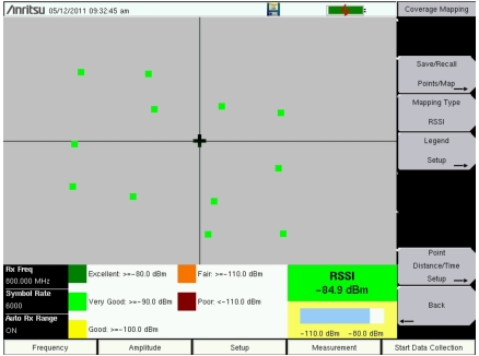
The instrument is able to make coverage mapping measurements even when an Anritsu easyMap Tools file of the current indoor or outdoor location is not available. In such cases, use the default grid map, save the KML points, and recall them at a later time with a map. Figure: Coverage Mapping with the Default Grid. shows a default grid in the measurement display. Refer to Mapping Save/Recall Menu for additional information on recalling saved maps and .kml data.
Note
When using the default grid, the coverage area for outdoor coverage mapping is fixed at 10 miles by 10 miles. For indoor coverage mapping, the grid size is the default grid image size, 640 pixels by 420 pixels.
1. Press the Measurement main menu key, then press the Coverage submenu key.
2. In the Coverage Mapping menu, press the Save/Recall Points/Map submenu key.