 | |
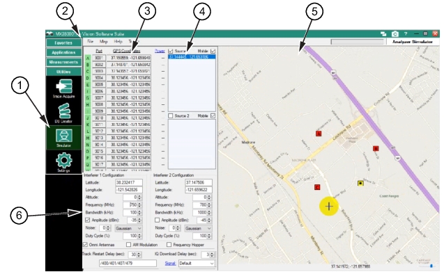
1. Simulator Menu Button 2. Menu Bar 3. Port and GPS Coordinates | 4. Source 1 and Source 2 Interferer Tracking 5. Map Window 6. Interferer Settings |
| |
1. Simulator Menu Button 2. Menu Bar 3. Port and GPS Coordinates | 4. Source 1 and Source 2 Interferer Tracking 5. Map Window 6. Interferer Settings |
Menu | Description |
File | Open Configuration File Open simulator files (*.sim), Tracking files (*.trx), and All files (*.*) Save Configuration File Save file to user selected folder location. New Configuration File (Clear) Clears content of the Source 1 and Source 2 lists Exit Exit the File menu. |
Map | Load Map Load a user selected map to the screen. Existing Maps Load a map from an existing map folder. |
Help | Help SeeHelp Menu. |
Tracking Points | Clear Track List Clear the track list. Import from file Import from user selected folder for Tracking files (*.trx; *csv, *.txt). Sort Tracks Sort tracks order from top to bottom or bottom to top. Step Through tracks Steps through the tracks one at a time. Step Interval Set step interval speed of each step to: |